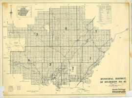
Affichage de 188 résultats

Description archivistique
12 résultats avec objets numériques Afficher les résultats avec des objets numériques
CA MHM 1984.87.01 · Pièce · 25 Jan 1904
Fait partie de Musée Héritage Museum maps and drawings collection

Fourth edition (corrected). Shows river lots and township system, part of HBC reserve. The information for this plan was compiled from official surveys dated 1882, 1883, 1885 and 1893. The plan was approved and confirmed by the Surveyor General. Gordon Sanders (1917-1993) is the father of St. Albert alderman Margaret Plain.

Interurban car barn plan, 1912
CA MHM 1992.41.02 · Pièce · 1912
Fait partie de Musée Héritage Museum maps and drawings collection

Printed on paper. Edmonton Interurban Railway St. Albert Line Car Barn drawings. The following drawings are on this sheet: Detail of Bumping Post Track No. 1 (Scale 1/2=1'0); Method of Framing Roof Timbers (Scale 1=1'0); Detail of Doors (Scale 1/2=1'0); Detail of Bumping Post Track No. 2 (Scale 1/2=1'0); Method of Framing Sil Joints Under Posts (Scale 1=1'0); Side Elevation (Scale1/8=1'0); Cross Section (Scale 1/8=1'0); End Elevation (Scale 1/8=1'0); Front Elevation ( Scale 1/8=1'0); Ground Plan (1/8=1'0); Roof Plan (1/8=1'0); and Longitudinal Section Through Track No. 1 (Scale 1/8= 1'0).

St. Albert street map, 2016-2017
CA MHM 2020.06.12 · Pièce · 2016-2017
Fait partie de Musée Héritage Museum maps and drawings collection

2016-2017 City of St. Albert street map and community guide. Includes advertisements, list and map of outdoor recreation facilities, tourist information and contacts, calendar of annual events, and a street map of St. Albert with churches, schools, shopping centres marked. Map produced by St. Albert Business and Tourism development.

St. Albert street map, 2011-2012
CA MHM 2020.06.10 · Pièce · 2011-2012
Fait partie de Musée Héritage Museum maps and drawings collection

2011-2012 City of St. Albert street map and community guide. Includes advertisements, list and map of outdoor recreation facilities, tourist information and contacts, calendar of annual events, and a street map of St. Albert with churches, schools, shopping centres marked. Map produced by St. Albert Business and Tourism development.

St. Albert street map, 2012-2013
CA MHM 2020.06.11 · Pièce · 2012-2013
Fait partie de Musée Héritage Museum maps and drawings collection

2012-2013 City of St. Albert street map and community guide. Includes advertisements, list and map of outdoor recreation facilities, tourist information and contacts, calendar of annual events, and a street map of St. Albert with churches, schools, shopping centres marked. Map produced by St. Albert Business and Tourism development.